In the beginning,
it would have seemed foolish to attempt crossing the Arctic
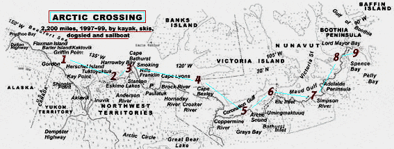
without maps. (Like the one you can find below this text --
a map which will give you access to photos I took on my journey)
-- I had 56 of them altogether. I made notes on each of them
about wildlife and strange landforms and hidden coves and sandstone
arches and meetings with remarkable Inuit. Once I even laid
them together and stood back for the big picture, looking down
as a high flying bird might see it: the bald pate of North America
stretching far from the forests, several villages glimmering
with pinpricks of artificial light, and most incredibly, I could
see the land curving back from the sea�showing the shape of
our planet. Collectively, I thought, the maps might really teach
me something.
The chink in my dream of soloing the Northwest Passage came
when I began to learn that singularly, the detailed maps were
not always correct. As the tide rose and fell, uncharted sandbars
appeared. Currents washed the sand away and created new sandbars
in different locations. The icepack sawed the coast apart
and lifted away prominent landmarks, then retreated north,
unmapable (even by the inaccurate weekly satellite sea ice
maps) because of its hourly fluid and grinding mutations.
Pingo ice hills, looking like miniature volcanoes, disappeared
as underlying permafrost melted. Floods carved new river channels
out into the sea. Rivers shown as starting miles north of
treeline mysteriously carried driftwood to the coast I was
paddling. Bays drained. And storms washed away whole beaches.
An Inuk man from Tuktoyaktuk showed me some pointers on my
map, penciling a precise line across the peninsula, zigzagging
the pencil across the map's landscape and describing the shape
of hills, erasing then re-penciling two sections, then decrying
the inaccuracies of this particular map, "Government never
quite gets it right," he said. The Inuk, who had never graduated
from high school, had shown me all the expertise of a famous
cartographer, who had once given me similar advice.
During the last summer of my 2,200 mile journey, while I
studied my one-to-fifty thousand scale maps, another Inuk,
from Cambridge Bay, gave me his one-to-a half million-scale
jetliner pilot map. I asked him if his smoky-smelling map
had enough detail to show what I needed to know. He laughed.
Then his prophetic words, along with the map, would accompany
me for another two months.
The map was so crispy and old with age that it flaked apart
each time I unfolded it, but again, it was as if I was looking
down and seeing the top of the continent from above the troposphere.
The Inuk had told me that his map was the way elders learned
to see the land. Just like the sandhill crane.
Here is a version of the map made for the book, and I invite
you to click on the numbers, following my trip, west to east,
and take a look at some of the sights I grew familiar with
along the way...
---Jonathan Waterman, November 2000